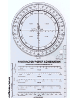
These useful see-through map cards are great for reading bearings, distances and grid references on 1:25,000 1:50,000, 1:100,000 and 1:250,000 scale maps. The roamer can be purchased as a single unit or as part of the Map Reading Guide. A romer can be used for determining the last Easting and last Northing figures for a six-figure grid reference. Place the top right hand corner intersection of the roamer lines over the point of interest, read the numbers from this point to the left to give the final Easting figure and down to give the final Northing figure. The number required is the last number read before the grid line on the map crosses the romer.
 Enlarge