New South Wales & Act
-
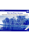
Murray River Access Book No. 11
Ulupna Island - Barmah - Edward River - Mathoura - Deniliquin. This book includes good mapping (GPS…
$10.00
-
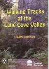
Walking Tracks Lane Cove Valley STEP
This full-colour, double-sided map shows bush tracks, cycleways and fire trails with connecting…
$20.00
-
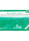
Murray River Access Book No. 12
Jingellic - Walwa - Tintaldra - Corryong - Khancoban - Murray Source. This book includes good mapping…
$10.00
-
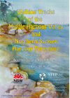
Walking Tracks Middle Harbour Valley & Northern Sydney 3&4 STEP
1:10,000 scale Middle Harbour Valley & Northern Sydney Harbour Foreshore - Northbridge &…
$20.00
-
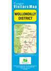
Wollondilly District Craigies
This map extends from Warragamba in the North to Yanderra in the South to Lake Burragorang in the…
$9.00
-
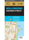
Wollongong UBD 299
This map covers Wollongong and it's surrounding suburbs and includes maps of Nowra and Berry and…
$12.00
-
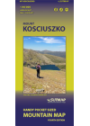
Mount Kosciuszko Perisher & Thredbo Sutmap
All year round map guide with alpine areas & ski resorts in great detail. Ideal for bush…
$17.00
-

Gangerang Wild Dog Mountains
Myles Dunphy's topographic map covers the Greater Blue Mountains of N.S.W.. It is a hand drawn map…
$12.00
-
Murray River Access Book No. 1
Yarrawonga - Mulwaa - Cobram - Barooga - Tocumwal - Ulpena Island. This book includes good mapping…
$10.00
-
Murray River Access Book No. 2
Barmah - Echuca - Moama - Torrumbarry Weir. This book includes good mapping (GPS compatible) and…
$10.00
-
Murray River Access Book No. 4
Gunbower Island - Cohuna - Barham - Koondrook - Murrabit. This book includes good mapping (GPS…
$10.00
-
New South Wales, Victoria & Tasmania ITMB
This map bi ITMB @ 1:900,000 is a double sided map of South East Australia covering all of NSW…
$20.00
-
Gundungura Map
3rd Edition 1970 Old Black & White Sketch map compiled by Sydney University Rover Crew and…
$15.00