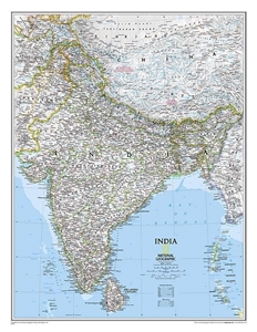
India wall map from the National Geographic Society, size 61 x 76cm, on a light base with both internal state boundaries and international borders shown in colour.
Coverage includes all of Nepal, Bhutan and Bangladesh, plus most of Tibet, eastern and northern Pakistan, Sri Lanka, etc. Disputed international borders between with Pakistan and China are marked. City names are given in their current version with the historical names in brackets; Kolkata (Calcutta), Varanasi (Banaras), Kochi (Cochin), etc.
Topography is indicated by relief shading with names of various mountain ranges, peaks (heights in metres), etc. National parks are highlighted. The map shows the network of main road and rail connections and indicates locations of airports. Latitude and longitude lines are drawn at 4° intervals.
 Enlarge