 Enlarge

Patagonia Rail & Road ITMB
$22.00
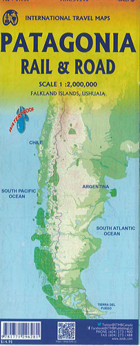
Patagonia and Tierra del Fuego on a double-sided map from ITMB showing the mainland on both sides of the Chile – Argentina border @ 1:2,200,000. Both sides show the topography by altitude colouring with plenty of names of mountain ranges, islands, straights and bays, etc.
On one side is an indexed map at 1:2,200,000 covering South America southwards from Buenos Aires in Argentina to Puerto Murta in Chile. Topography is presented by altitude colouring, with graphics indicating national parks and other protected areas. The map shows the regions’ road network, including selected tracks and seasonal roads, as well locations accessible by air services and shipping routes from Puetro Montt along the Chilean fjords. Numerous places of interest are marked, some annotated with brief notes.
On the reverse ism the southernmost part of the continent. The map indicates border crossings between the two countries, presents the road network with locations of fuel supplies, and shows local airports/airfields and ferry connections. Symbols indicate locations with tourist accommodation, shelters and campsites, beaches, and other places of interest. The map is indexed and also includes inset maps of central Ushuaia indicating locations of hotels and other tourist facilities & the Falkland Islands (Islas Malvinsa).